Table of Contents
Rainfall Definition
Rain is a form of precipitation and an element of climate that falls in liquid state, it is the amount of water that falls as rain on an area over a period of time, Other forms of precipitation include frost, dew, mist, haze, fog and snow. Different places on the earth surface receive different amounts of rainfall in a year, for instance, as we move from the equator towards the poles, the amounts of rainfall tends to decrease steadily. Some areas of the world such as the coastal regions, receive more rainfall than the interior of the coast. However, rainfall is greater on the coastal plain, on the windward side and decreases towards the leeward side. Rainfall is an important element of climate, the natural vegetation depends upon the amount of rain that falls, how constant the rain is, its length and how it falls. Rain is also an important source of water for ocean, river, underground water, man and other living things depend on it for their daily growth.
How is rainfall formed?
When the saturated air going up becomes cool and condensed, it transforms into cloud. A cloud contains innumerable water and ice particles. These water and ice particles coalesce together to form a bigger size of water particles which due to gravitational force fall on the earths surface as rain. Basically, there are three types of rain such as : convectional, orographic, cyclonic or frontal rainfall.
Measurement of rainfall
Rainfall is measured by an instrument called rain gauge, a rain gauge consists of a metal container, a metal jar or glass bottle and a metal funnel. To obtain accurate measurement, the instrument is usually kept in an open space far away from buildings and trees or shelter. This is to enable the rain gauge collect rain water directly without any interruption. Another reason why this is kept away from buildings or trees is to ensure that no water drops from the roof of the building or trees into the funnel after the rain has stopped. The rain gauge is examined everyday and daily records are taken for proper documentation. The instrument is sunk into the ground and firmly held in position such that 30cm of it is above the ground level. A line used on maps to join places having the same average annual rainfall is called ISOHYET.
Rainfall data
Data of rainfall are usually taken at the meteorological stations to determine the intensity of rainfall, evaporation rate, daily, monthly and mean annual rainfall.
Types of rainfall
There are three types of rainfall formed as a result of condensation of water vapour, they include:
- Convectional rainfall
- Orographic or relief rainfall
- Frontal or cyclonic rainfall
Convectional rainfall
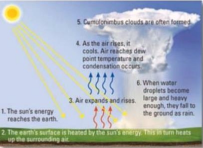
This is the type of rainfall that is very common in regions of extremely high temperatures and it occurs mainly in the day time. For example, it occurs in the tropic as during the summer period in the temperate interiors. When the earths surface is heated, the air expands and rises and becomes lighter. After a long period of intensive heating, the air will be forced to rise thus carrying into the upper atmosphere water vapour. The rainfall which is caused due to condensation of the water vapour is known as Convectional rainfall. At the upper atmosphere, the water vapour condenses into cumulonimbus clouds and later turn into water droplets. It should be noted here that a hot rising air has a tremendous capacity to hold moisture , which is a characteristic of regions having high relative humidity. Where the droplets becomes quite heavy for the upward movement. It falls back as rain and is often accompanied by thunder and lightning.
Convectional rainfall has some common features which are as follow:
- It is normally accompanied by lightning and thunder
- Convectional rainfall is usually torrential
- It occurs in the equatorial region and tropical monsoon
- This type of rain occurs in the afternoon
- It falls within a short distance
Orographic rainfall
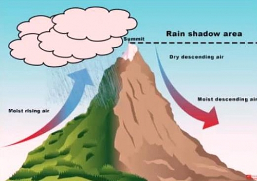
Orographic rainfall is experienced whenever moisture-laden air is forced to ascend a mountain barrier. Warm moist air coming from or over the sea carries tremendous amount of moisture. The air upon reaching the land surface is compelled to move to the upper atmosphere particularly when it comes in contact with a mountain barrier. As the air ascends higher into the upper atmosphere, it cools by expansion coupled with a decrease in atmospheric pressure. The air is further cooled so that it becomes wholly saturated. Condensation at this point sets in thereby forming clouds and finally rain. This type of rainfall is caused by mountain barrier or relief), hence it is called relief rainfall. However, the side of the mountain from which the wind is blowing is called the rain-bearing side or the windward side. The resultant rain is experienced only on the windward side whereas on the other side on which the wind descends brings no rain but rather a hot, dry wind. This side is called the leeward side.
Frontal or Cylclonic rainfall
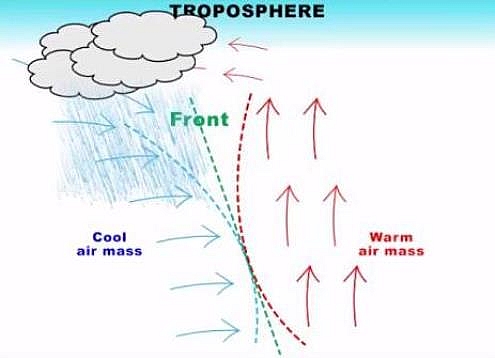
This type of rainfall is neither caused by orographic nor convectional. It is purely associated with two different air masses of varying temperature difference. It is a convergence of two characteristically different air masses or other physical properties. The meeting of tropical warm air and polar cold air usually ends in this type of rainfall.
Now, the warmer moist air which is lighter in weight rises when it meets the heavier denser dry air along the front. The front is the point of convergence, that is, the meeting point of air masses. The denser air will under-cut the lighter air and forces the later to rise and when such situation takes place, a low pressure condition is created so that the temperature of the warm air will cause the moisture in the air to condense and clouds are therefore formed and when cooling is below the dew point, it brings a bout rainfall. Cyclonic rainfall is common between altitude 500N- 700N and 500S- 700S of the equator.


