Nigeria has two main relief regions: the uplands or high plateaux ranging between 300m and more than 900m above sea level and the Lowlands, which are generally less than 300m above sea level. Most of the countrys rivers take their sources from four main hydrological centres: the North Central plateau (Sokoto-Rima, Hadejia, Gongola, and Kaduna rivers etc.), the Western Uplands (Moshi, Awun, Ogun, Osun, Osse rivers etc.), the Eastern Highlands (Katsina-Ala, Donga rivers, etc.) and the Udi Plateau (Anambra, Imo and Cross-river etc).
Table of Contents
The uplands (High Plateaux) in Nigeria include
- The western uplands
- The north-central plateau
- The eastern uplands
- north-eastern high- lands
The Lowlands in Nigeria include
- Niger-Benue trough
- The Niger Delta
- The coastal lowlands
- The Chad basin
- The undulating plains of the interior low- lands
- The scarplands of south-central Nigeria
- The Sokoto plains
All the lowlands in Nigeria are grouped into seven (7) category which I have listed above, however in todays article, we are going to consider a very important lowland in Nigeria which is the Benue trough.
Definition of aTrough
A trough is a narrow depression on the earth surface that extends over a distance. A trough could be a region on the surface of the earth that is characterised by relatively lower atmospheric pressure and it is often associated with fronts. A trough can bring about cloudy weather condition, precipitation and cold air within a specific area. A trough is mostly found in regions that experience colder air mass. The density of the air changes with temperature, as the temperature of air-cools and becomes denser and more compacted (takes up less volume). Thus, as air-cools the height lowers since the air is becoming denser. Air will cool when it rises, thus a trough can be found where there is a lifting of air.
Overview of BenueTrough
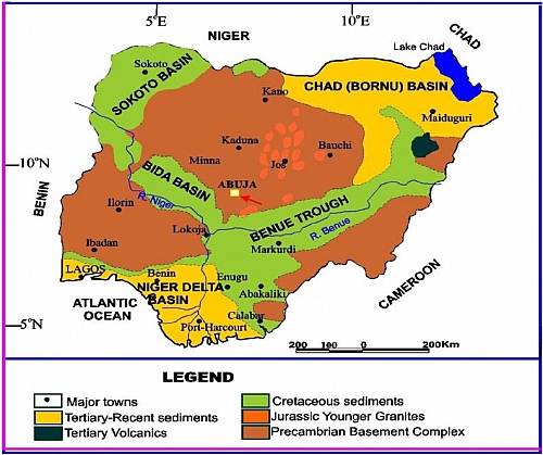
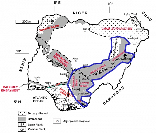
The Niger Benue trough is an important and unique rift feature that occupies a large part of Nigeria; it was formed from early Cretaceous rift complex known as the West and Central African Rift System. This trough covers an area of 1500km2 and it extends to a distance150km. Benue trough occupies an intercontinental position and has a compressional folded cretaceous supracrustal fill (rocksthat were deposited on the existing basementrocksof the crust). The Benue trough is located north of the scarplands of south-central Nigeria of physical and Human Characteristics and south of the north-central plateau; it runs from the southern boundary of the Sokoto plains in the north-west to the north-east near Yola, having passed through Lokoja from where it extends south to the Onitsha gap, north of the Niger Delta. Benue Trough comprises of majorly states in the Central and North-eastern parts of Nigeria such as Bauchi, Benue, Gombe, Kogi, Nasarawa, Plateau and Taraba States etc. The Benue trough is divided into three regions in Nigeria, lower, middle and upper regions; hence, the upper region is further divided into the Gongola and Yola arms.
Benue trough surface lies below 300m above sea level, and it is underlain by sedimentary rock. Denudation actions by the Niger-Benue river system liberate enormous alluvial sediments to form extensive flood plains along the trough. The area is thus good for agricultural activities; it has much water for irrigation farming and it is a major source of fish. The immense surface and ground water resources left virtually untouched along the Benue basin of the trough call for careful exploitation and utilisation for maximum benefits. Get more explanations on the formation of Benue trough here.
Economic importance of the Benue trough
- The Nigeria relief feature plays essential role on the formation of rocks, soil, vegetation and it also has influence the climatic conditions of the areas around it.
- The Benue trough could serve as important location for the discovery of oil and gas and other important mineral deposits; most of these mineral deposits (coal) are mined in f Enugu State and in other parts of the country.
- Lowlands serve as a comfortable habitat for man settlement; it enables the construction of communication networks like railways, airports, and road and for mounting of telecommunication masks.
- Benue trough also favours intensive agricultural activities due to it depositional plains which are rich fertile soil.
- Areas found in these lowlands are rich in earth minerals such as rocks of various types which include alluvial deposits, limestone, sand stones, shale and clay etc.
Picture References
- Map of Nigeria showing sedimentary basins and the location of the Benue Trough including the Anambra Basin bywww.omicsonline.org
- Map of Nigeria showing uplands and lowlands from a reseach article byscialert.net.
- Gongola basin upper Benue trough around gombe by Abdulrahman Hilal.
- Mapping of hydrocarbon potential in Middle Benue Trough by Ikenya Ishaya.
- Mapping of Lower Benue Trough in the search for Bentonite and Kaoline solid minerals by Prince Ogbonna


