Table of Contents
Latitude Meaning
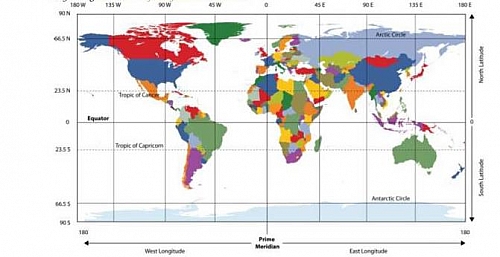
Latitude in Geographyis animportant topic that we often come across. You can easily determine the location of a place with the help of latitude and longitude. With the location of the longitude, one can determine the time of that place,however, the northern and the southern position of any place can be determined through the use of latitudes, while the western and the eastern position of any location from the Prime Meridian can be ascertained by longitude. Degree of latitude or a part of it is known as the latitude, while the degree of longitude of a part of it is termed as longitude.
What is latitude and longitude?
Latitude and longitude are some imaginary lines running from east to west and from north to south respectively drawn on a map of the world, this lines can be used to determine the location of any place. These lines are known as the parallels of latitude and the meridians of longitude respectively.
Latitude meaning
Latitude is an imaginary line drawn on the globe running from east to west. Latitude is usually measured in degrees since it represents angular distance of a point on the earth surface from the centre of the earth. Before one can have a full knowledge of latitude, he or she will need to have an idea about the axis, the equator and parallels of latitudes.
Axis– this is an imaginary line which runs north to south through the centre of the earth. The northernmost point of this axis is known as the north pole and the southernmost point is the south pole. Keeping both the poles in equal distance.
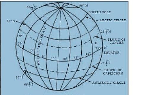
Equator– the equator is the largest circle of latitude on Earth, it encircles the globe from west to east, this is also called the terrestrial equator. Due to the shape of the earth (spherical earth), this line is also circular. So, this line is also known as the equatorial circle. The equator divides the earth into two equal halves and is called 0 degrees latitude. The part lying north to the equator is known as the Northern Hemisphere, while the part lies to the south is known as the Southern Hemisphere. There are other lines of latitude and are numbered from 00 to 900 going toward each of the poles. The lines north of the equator toward the North Pole are north latitude, and each of the numbers is indicated by the letter N. The lines south of the equator toward the South Pole are south latitude, and each of the numbers is indicated by the letter S. The equator (0 latitude) is the only line of latitude without any letter following the number.
Notice that all lines of latitude are parallel to the equator (they are often called parallels) and that the North Pole equals 900 N and the South Pole equals 900 S. The latitude of the region near the equator, in other words, the latitudes having the value of 0 to 30 are called the low latitudes. While, latitudes having the value of 30 to 60 are known as the mid latitude and those of 60 to 90 are the high latitudes.
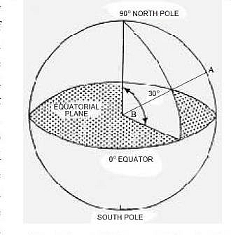
With the help of the equator, you can determine the angular distance of a place situated either in the northern or in the southern hemisphere depending on where you stand. For example, to find out the angular distance of a place upon the surface, all you need to do is to connect with an imaginary line at any point of that place with the centre of the earth. However, the meridian which crosses over that point ultimately meets the equator on a certain point, and that the meeting point is connected by an imaginary line with the centre of the earth.
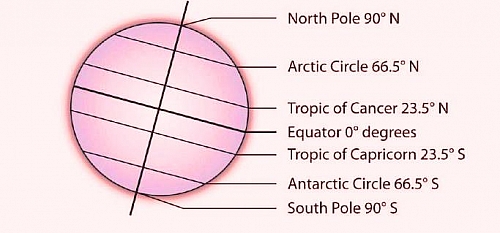
The imaginary line is actually the radius of the earth sphere. The value of the angle that is formed through those two lines is equivalent to the latitude of that particular place. Therefore, the latitude is the angular distance of a place north or south of the equator. If a line is drawn from any place on the earth to its centre then that line will create an angle with the equatorial plane. The value of that angle is the latitude of that place. The latitude of a place situated to the north of the equator is designated as the north latitude and that of the south as the south latitude. The total value of the angle created by the circle at the centre of the earth is 360. These angles are being divided into degrees (0), minutes (‘) and seconds (“). However, the value of the equator is 0. The latitude of the north pole is 90 North and that of the south pole is 90 South. This is because that the angular distance of each of the poles is 90 from the equator. These angles are being divided into degrees and minutes and on the basis of these angles, the imaginary lines are drawn parallel to the equator. These are known as the parallels of latitudes. All lines of latitude are parallel to each other and every one of them is a full circle. The circumference of the latitudes decrease with the increase of their values. Some of the parallels are quite important. Latitude in the northern hemisphere is known as the Tropic of Cancer , while latitude in the southern hemispheres is known as the Tropic of Capricorn. Besides, the 66.5 north and south latitudes are known as the Arctic and Antarctic circles respectively. The degree of latitude of all the places located in the same parallel is the same.
Important Lines of Latitude
- The equator is usually numbered 0o
- The tropic of cancer 23 0N
- The tropic of Capricorn 23 0S
- The arctic circle 66 0N
- The Antarctic circle 66 0S
- The North and South poles 900N and 900S respectively
Equator as a line of Latitude
The equator is the largest circle of latitude on Earth, it divides the earth into the Northern and Southern Hemispheres and it is also called 00 of latitude.
Tropic of Cancer as a line of Latitude
This is the parallel at 23 0N of the equator, which is the most northerly place on Earth, receiving direct sunlight during the Northern Hemispheres summer. Remember that the earth is tilted 23 0, which accounts for seasonal variations in climate.
Tropic of Capricorn as alines of latitude
This is theparallel at 23 0 S of the equator and is the most southerly location on Earth, receiving direct sunlight during the Southern Hemispheres summer. The tropics Cancer and Capricorn are the two imaginary lines directly above which the sun shines on the two solstices, which occur on or near June 20 or 21 (summer solstice in the Northern Hemisphere) and December 21 or 22 (winter solstice in the Northern Hemisphere). The sun is directly above the Tropic of Cancer at noon on June 20 or 21, marking the beginning of summer in the Northern Hemisphere and the beginning of winter in the Southern Hemisphere. The sun is directly above the Tropic of Capricorn at noon on December 21 or 22, marking the beginning of winter in the Northern Hemisphere and the beginning of summer in the Southern Hemisphere. Solstices are the extreme ends of the seasons, when the line of direct sunlight is either the farthest north or the farthest south that it ever goes. The region between the Tropics of Cancer and Capricorn is known as the tropics. This area does not experience dramatic seasonal changes because the amount of direct sunlight received does not vary widely. The higher latitudes (north of the Tropic of Cancer and south of the Tropic of Capricorn) experience significant seasonal variation in climate.
The Arctic Circle
This is a line of latitude at 66 0 N. It is the farthest point north that receives sunlight during its winter season (900 N 23 0 = 66 0N). During winter, the North Pole is away from the sun and does not receive much sunlight. At times, it is dark for most of the twenty four- hour day. During the Northern Hemispheres summer, the North Pole faces more toward the sun and may receive sunlight for longer portions of the twenty-four-hour day.
The Antarctic Circle as alines of latitude
This is the corresponding line of latitude at 66 0S. It is the farthest location south that receives sunlight during the winter season in the Southern Hemisphere (900 S 23 0 = 66 0 S). When it is winter in the north, it is summer in the south. The Arctic and Antarctic Circles mark the extremities (southern and northern, respectively) of the polar day (twenty-four-hour sunlit day) and the polar night (twenty-four-hour sunless night). North of the Arctic Circle, the sun is above the horizon for twenty-four continuous hours at least once per year and below the horizon for twenty-four continuous hours at least once per year. This is true also near the Antarctic Circle, but it occurs south of the Antarctic Circle, toward the South Pole.
North and South poles lines of latitude
These are the north most point and the south most point of the axis that runs through the center of the earth
Calculation of Distance of Latitude
To calculate the distance using lines of latitude the following should be adhered to strictly:
- Locate the two points in the question for example: 150N and 420N on the same longitude
- Get the difference between the two points on the globe. For example: 200N and 420N respectively.
Note that whenever the two places or points are North of the equator, we subtract their latitude and the same procedure is applicable for the south of the equator. However, there may be a situation where the points indicated may be north and south of the equator, in this case, all you need to do is to add the latitude of the two places.
Example: Assuming town A lies on latitude 170N while town B lies on latitude 270S on the same longitude all you need to do is to add both locations
170 + 270= 440
The distance between 10and another is 111km using the equatorial circumference of the earth
For instance, 40080/ 360 km= 111km approximately. In this case, whatever unit of degree you arrived at, you are to multiply it by 111km.


