Table of Contents
International date line definition
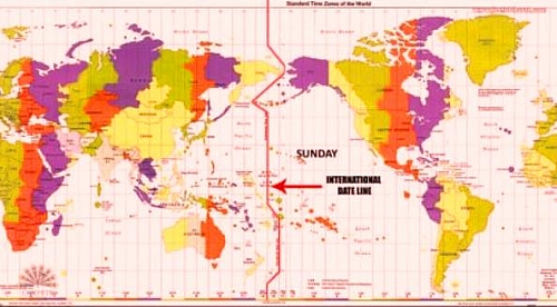
This is an imaginary line running from North pole to South pole through the mi-Pacific Ocean. The international date line is not straight, the line appears to be zigzag in some places, this is to avoid some island groups from counting two different local times in two different parts of the same island, thereby removing the confusion of dividing one island into different dates. The meridian at 180 degrees is called the International Date Line. The International Date Line (180 degrees longitude) is opposite the prime meridian and this indicates the start of each day (Monday, Tuesday, etc.).
What happens when you cross the international date line?
When the international line is crossed a whole day is either gained or lost. Crossing international date line to the East means a day is gained while crossing it to the West means a day is lost. To the travellers going west of the international date line on Monday 16th, crossing the international date line that date and day becomes Tuesday 17th, while those crossing to the East on Monday the 16th, the date and day becomes 15th.
Officially, each day starts at 12:00 a.m., at the International Date Line. It is important to understand the International Date Line and not to confuse it with the prime meridian which is the 00 longitude. The actual International Date Line does not follow the 1800 meridian exactly. A number of changes have been made to the International Date Line to accommodate political agreements to include an island or country on one side of the line or another.
Importance of international date line
The international date line is very important for time measurement, global interconnectivity, instantaneous communication, and consistent international databases. It’s mostly about convenience, commerce, and politics. It functions also as line of demarcation, dividing two consecutive calendar dates
The International Date Line sits on 1800 east and west line of longitude. This line crosses through the Aleutian on the north-eastern part of Siberia, Fiji and Chatham islands. To prevent the problems of adjusting local time, the International Date Line has been designed so that it will pass only over the water bodies turning 120 towards east just near the Bering Strait, 70 towards west near the Aleutian islands and 110 towards east near Fiji and Chatham islands. If the line wasnt drawn this way, a lot of people would have to count two different local times in two different parts of the same island.
